

Counting the waves…
Counting the waves…
A refined fusion of water purity, environmental stability, and communal vibrancy for Dead Man Beach.
View MethodologyAnalyzed via live sensors and environmental data.
Wave height, wind, and atmospheric stability.
Live footfall and crowd balance metrics.
Community reviews and curated sentiment.
“The Horseshoe Point track descends through scrub forest to a cove framed by granite headlands and scattered with massive boulders. The name alone—Dead Man Beach—carries shipwreck gravity, but the reality is pure Stewart…”
Limited recent visitor reports — live OBI telemetry is your best guide for current conditions.
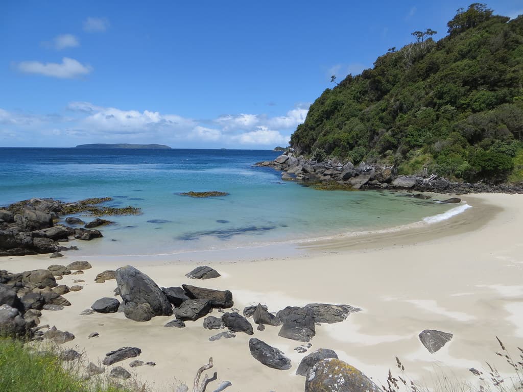
Dead Man Beach earns its name from nineteenth-century maritime tragedy, though the modern experience is less ominous than evocative. You reach it via the Horseshoe Point track, a route that undulates through coastal forest before dropping toward the shore. The beach itself is small—perhaps seventy meters across—and backed by a low scrub-covered bluff that blocks views inland while framing the ocean dramatically. Granite boulders, some the size of cars, sit scattered across the sand and waterline as if dropped carelessly by geological forces beyond human scale.
The cove faces northeast across Paterson Inlet's mouth, catching morning light that illuminates the water in layers—pale green shallows, deeper blue channels, dark kelp beds visible beneath the surface. At low tide, rock platforms extend from both headlands, their surfaces pocked with tide pools hosting anemones, small fish, and purple-spined urchins. Bull kelp anchors to the offshore rocks, its bladders forming floating forests that sway with tidal currents. The wind here funnels through the cove's geometry, sometimes whistling between boulders with an eerie resonance.
Person walking on a sand spit
Aerial view of turquoise tropical bay
Massive rock formations photograph
Continues around coastal circuit
Low tide reveals marine life
Prime Visitation
Best Weather|Less Crowds
Where it is
Dead Man Beach
Stewart Island / Rakiura, Southland, New Zealand
-46.870100°, 168.117500°
Weather
Loading…
Swell
—
Temp
Warm · Restorative
UV Index
Moderate
Wind
—
Tidal State
Last known
Max Sunlight
—
Ideal Shade
—
Jan - Dec (Peak)
Mar - Nov (Off-season)
Best Weather|Less Crowds
Near Dead Man Beach
Explore dining, stays, nightlife, and activities near Dead Man Beach in Stewart Island / Rakiura, New Zealand. Every listing below is a real place linked to this beach — open a card for reviews, maps, and booking options.
Stays and lodging options near Dead Man Beach for your beach trip.
Activities, tours, and attractions near Dead Man Beach.
Select a category to load nearby places.
Unlock restaurants, luxury stays and curated maritime experiences within 2km
Swimming at Dead Man Beach is not recommended due to its exposed location, cold sub-Antarctic waters, strong currents, and lack of nearby facilities or rescue services. The beach is isolated and accessible only by tramping track, meaning emergency assistance would be significantly delayed. The water temperature remains cold year-round, and conditions can change rapidly. The beach is best appreciated for its dramatic scenery and as a destination point on the Horseshoe Point walking track rather than as a swimming location. Always prioritize safety in this remote wilderness setting.
The optimal time to visit Dead Man Beach is during New Zealand's summer months (December to February) when weather is most stable and daylight hours are longest for the walk. However, Stewart Island's weather is notoriously changeable year-round, so be prepared for rain, wind, and cooler temperatures even in summer. Spring and autumn can offer good conditions with fewer visitors. Winter visits are possible but require more experience and preparation due to shorter days, rougher seas, and increased storm activity. Always check weather forecasts before setting out on the track.
Dead Man Beach is accessed via the Horseshoe Point walking track, which begins near Oban, Stewart Island's main settlement. To reach Stewart Island, take a ferry from Bluff (approximately one hour) or a flight from Invercargill (20 minutes). The walk to Dead Man Beach typically takes 2-3 hours one way, covering moderate terrain through native bush before emerging at the coast. The track can be muddy and requires reasonable fitness. Most visitors make it a day trip from Oban, allowing 5-6 hours total for the return journey with time to explore the beach.
There are no facilities, food, or accommodation at Dead Man Beach itself—it's a remote wilderness location. All services are based in Oban, Stewart Island's only township, where you'll find lodges, backpackers, holiday homes, a general store, cafes, and restaurants. Visitors should pack food, water, and supplies for the day walk to Dead Man Beach. The track has no shelters or amenities, so carry everything you need. Book accommodation in Oban well in advance, especially during summer months, as options are limited and the island is popular with trampers and nature enthusiasts.
While the origin of the name 'Dead Man Beach' isn't definitively documented, such names often reference historical shipwrecks or tragedies common on New Zealand's rugged southern coasts. The beach is valued for its dramatic, untouched beauty, with wild surf, rocky outcrops, and dense native forest meeting the ocean. It's a highlight for photographers seeking moody coastal landscapes and trampers exploring Stewart Island's wilderness. The relative isolation and effort required to reach it means you'll often have the beach to yourself, offering a genuine sense of remoteness and connection to nature rarely found elsewhere.
Photos