Counting the waves…
Counting the waves…
A refined fusion of water purity, environmental stability, and communal vibrancy for Tom Nevers Beach.
View MethodologyAnalyzed via live sensors and environmental data.
Wave height, wind, and atmospheric stability.
Live footfall and crowd balance metrics.
Community reviews and curated sentiment.
“You'll feel the difference the moment you leave Nantucket's historic core and hit the scrubby moorland leading to Tom Nevers. The Atlantic wind hits harder here, carrying salt spray across dunes that shelter one of the…”
Limited recent visitor reports — live OBI telemetry is your best guide for current conditions.
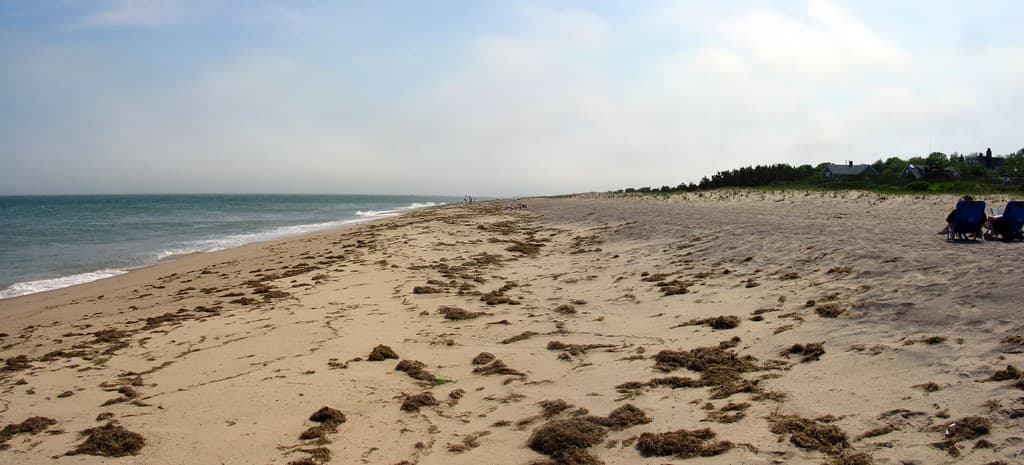
Tom Nevers occupies a stretch of Nantucket's exposed southern shoreline where the island sheds its postcard prettiness for something more elemental. The beach unfolds in a long, gently curving sweep backed by low dunes and beach grass that bends perpetually eastward under prevailing winds. Unlike the protected harbors and calm bays that draw the summer crowds, this coast faces open ocean, and you feel it—in the persistent breeze, the steady drum of waves, the absence of anything between you and Portugal.
Surfers know Tom Nevers for its dependable beach break, which fires on northeast and southeast swells throughout the year. The sandbars shift with storms, creating peaks that can hold size when conditions align. In summer, the water temperature climbs into the sixties; by November, you're looking at the low fifties and reaching for thicker neoprene. The crowd factor stays mercifully low, even in high season, partly because most visitors never venture this far from town, and partly because the conditions demand respect.
A jellyfish washes up on the shore.
waves crashing on a beach
Shifting sandbars create reliable peaks
Strong swimmers only, watch currents
Wind-sheltered spots behind beach grass
Where it is
Tom Nevers Beach
Nantucket, Massachusetts, USA
41.254600°, -70.023500°
Weather
Loading…
Swell
—
Temp
Warm · Restorative
UV Index
Moderate
Wind
—
Tidal State
Last known
Max Sunlight
—
Ideal Shade
—
May - Sep (Peak)
Jan - Dec (Off-season)
Historical data suggests peak visibility and stable sea temperatures occur during the prime visitation window.
Near Tom Nevers Beach
Explore dining, stays, nightlife, and activities near Tom Nevers Beach in Nantucket, USA. Every listing below is a real place linked to this beach — open a card for reviews, maps, and booking options.
Food, cafés, and dining close to Tom Nevers Beach — curated from places linked to this beach.
Stays and lodging options near Tom Nevers Beach for your beach trip.
Activities, tours, and attractions near Tom Nevers Beach.
Select a category to load nearby places.
Unlock restaurants, luxury stays and curated maritime experiences within 2km
Tom Nevers Beach faces the open Atlantic, creating strong currents, undertow, and larger waves compared to Nantucket's north shore beaches. There are no lifeguards on duty, so swimmers should exercise caution and stay close to shore. The beach is popular with surfers precisely because of these conditions. Families with young children may prefer calmer beaches like Jetties or Children's Beach. Always check weather conditions before visiting, and never swim alone. The lack of crowds means help may not be immediately available in emergencies.
Tom Nevers Beach is accessible year-round, with each season offering different experiences. Summer (June-August) brings warmest water temperatures around 65-70°F, though the beach remains less crowded than other Nantucket spots. Fall delivers excellent surfing conditions with consistent swells. Spring and winter offer solitude for beachcombing and walking, though water is quite cold. Fog is common in summer mornings, typically clearing by midday. For swimming, visit July through early September. For surfing or peaceful walks, shoulder seasons provide ideal conditions with fewer visitors.
Tom Nevers Beach is located on Nantucket's southeastern shore, about 5 miles from downtown. From town, take Milestone Road east, then turn right onto Tom Nevers Road, following it to the end. A small parking area accommodates around 20 vehicles and is free year-round. The lot fills quickly on summer weekends, so arrive early. The beach requires a short walk over dunes from the parking area. No public transportation serves this beach directly, so you'll need a car, bicycle, or taxi to access it.
Tom Nevers Beach has no facilities—no restrooms, showers, concessions, or rentals. It's a true natural beach where you must bring everything you need, including water, food, and shade. The nearest commercial area is back toward town, about 5 miles away. Several vacation rental homes dot the Tom Nevers neighborhood, offering private accommodations within walking distance. The Miacomet area, a few miles west, has a golf course clubhouse with food. Plan ahead and pack supplies before heading to this remote, undeveloped beach.
Tom Nevers Beach is one of Nantucket's best surf spots due to its southern exposure to Atlantic swells and relatively consistent waves. The open ocean orientation means it picks up more swell than north-facing beaches, especially during fall and winter nor'easters and hurricane swells. The beach break works best at mid to high tide. While not massive, waves here are more reliable than most Nantucket locations. The uncrowded conditions appeal to surfers seeking solitude. Water temperatures require wetsuits most of the year, with spring suits sufficient only in late summer.
Photos